Plan your mission
The modern and platform-independent web application to visualize and plan military exercises and missions. Draw, save, export and exchange military map overlays or common operational pictures (COP) in map.army. To test the latest version navigate to
www.map.army.
Visualize your Mission
The Web Application provides the required functionalities to plan and visualize a military or stability operation mission and exercise.
The App is designed to be used on a Desktop, Notebook, Tablet or even a Touchscreen Mobile Phone - you decide on which device you plan the mission.
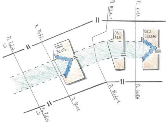
Military Map Overlay
One or more Military Map Overlays can be added in the App. All layers are visible and one of the layers is in edit mode (active). You can draw on the active layer using the Symbol Edit functions on the right side of the window.
The Military Map Overlays is saved in the MilX format. This format can be used to exchange Military Map Overlays with other systems. It is also possible to store the Layer locally or to share it via Email.
Search Military Symbol
Open the Military Symbol Search with a click on the Search-Icon on the right side of the window. The "Search for MSS Symbols" sub window opens. It provides all the functions to find the desired tactical graphic, unit, equipment, installation ...
A search can be done using the MIL-STD-2525 name of a symbol or by using the equipment name (for example, "F/A 18").
The search results are displayed in the right section of the window. For easier navigation the results can be filtered.
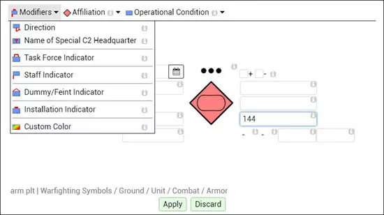
Edit Military Symbol
The Symbol Editor is opened with a click on the Edit button in the top right corner. MSS Symbol Editor provides access to the Modifiers and Attributes of the Symbol. The Text-Modifier are positioned around the Base Symbol in the position defined by the military standards.
The toolbar contains all the Non-Text Modifiers.
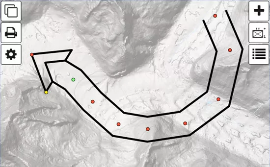
Draw Military Symbol
Select a Symbol to place or move it on the map. The function to edit a symbol are found in the bottom center part of the App. This includes the functions for add, move or delete reference points.
Check the short keys of the functions to become even faster in the edit of NATO symbols. The short keys for the symbol edit functions are found in the hint text of the buttons.
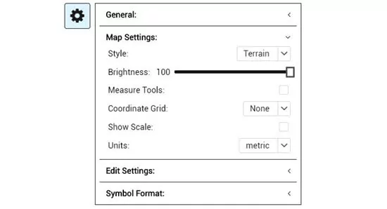
Map Settings
Open the "Map Settings" section in the main menu to change map style, the brightness of the map or the to change the units for distances from meters to miles.
Options
In the 'Options' section you can choose the Symbol Set to work with. Military Map starts with the MIL-STD-2525 Symbol Set by default.
In addition, the application language can be selected.
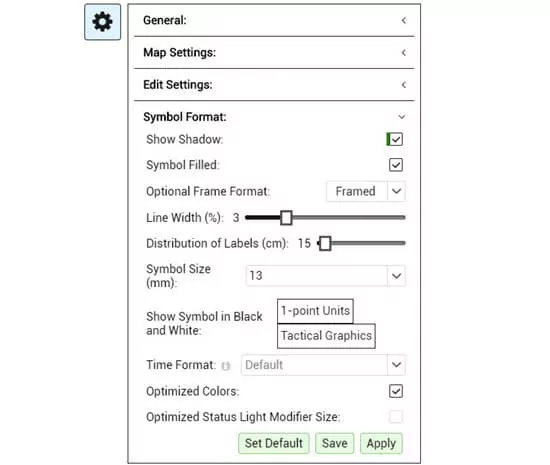
The ‘Symbol Format’ area is used to adjust the format options of the Military Symbols according to NATO standards. This includes parameters as ‘Line Width’ or the ‘Label Distribution’....
All changes to the default format can be stored to your session by using the save function in the bottom right of the 'Options' section.
map.army - Documentation
Discover our documentation of the web application. From beginners to military professionals - here everyone gets an answer.
What’s New
Here is a glimpse at the latest innovations - New functions or significant improvements are introduced in short cycles.
Create a share link to exchange a military map via URL. The application provides a simple method to create an iframe which can be added in a web page.
The web application supports custom image overlays. It is possible to add areal images (Ortho-Photos), georeferenced maps and non-georeferenced maps.
Vector layers in the formats GPX, KML, GeoJson and Json can now be loaded as military map overlays in the web application.
The latest version of the web application can be integrated into a web page or blog with just a few lines of code. In addition, military layers in MilX format can be loaded directly as URL parameters.
The military symbology in the web application supports now emojis in all the text modifier. This provides you with the possibility to customize tactical graphics or your unit symbol without breaking the military standards MIL-STD-2525 or APP-6.
The web application supports pins and text boxes. They can be placed on a military map overly to provide additional information. The content of the pin or text box is stored and exchanged in MilX (File Format for Military Overlays).
Contact us
Do not hesitate to contact us with your question of your feedback on map.army. Use the contact form or send your e-mail directly to mss@gs-soft.com.
Hint: Do you know the User Forum for the web application? The link can be found in the footer of this page.