On this page
The Point List — edit coordinates and danger zones
The Point List is the panel behind the View and edit graphic’s coordinates button. It is the place to work on a symbol numerically rather than by dragging it, and it is also where two things live that are documented nowhere else: the symbol’s direction, and the Safety Distance Zone controls.
Opening it
Select a symbol on the map, then press View and edit graphic’s coordinates in the main window.
The coordinate table
Every point of the selected graphic appears as an editable row. A single-point symbol has one row; a line, an area or a corridor has one per vertex.
- Coordinates are shown and accepted in whichever format you have configured under Options → Coordinate Settings. Switch the display format and the table re-renders in the new one — you do not have to convert anything by hand.
- Editing a row and applying it moves the point. This is the way to place a symbol on an exact grid reference rather than by eye, which matters for anything that will be fired at, flown to, or handed to another system.
- The edit goes onto the undo history.
Ctrl + Zreverses it like any other geometry change. See Keyboard shortcuts.
If the application cannot apply what you typed it reports Could not apply the points and leaves the geometry alone — the usual cause is a coordinate that does not parse in the format currently selected.
Direction
Where the selected symbol supports a direction — the MIL-STD-2525 Q modifier, drawn as a direction-of-movement indicator — the Point List exposes it as its own control.
The control only appears when the symbol actually supports that modifier. A symbol that has no direction concept simply does not show it, with no message, so its absence is not a fault.
Safety Distance Zones
For a single-point symbol, the Point List also carries the Safety Distance Zone controls: saved weapon types, ricochet area, vertical hazard and zone colours.
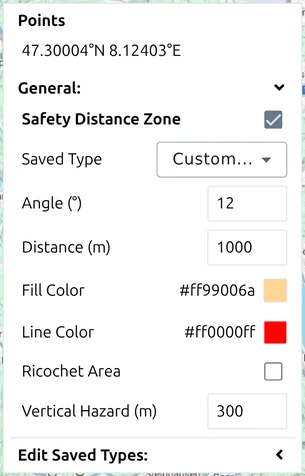
This is a substantial feature in its own right and has its own page — see Safety Distance Zones (SDZ).
Where to go next
- Point Editor — editing the geometry of a multi-point tactical graphic directly on the map.
- Safety Distance Zones — the live-fire planning aid this panel hosts.
- Coordinate settings — which format the table reads and writes.