On this page
Edit Multi-Point Tactical Graphics in map.army
Multipoint symbols are edited on the one hand directly on the map (position, extent) and on the other hand in the MSS Symbol Editor.
Overview
This chapter describes the editor for creating tactical graphics by adding and moving reference points.
Add tactical graphics
Use the following functions to add and edit tactical graphics:
| Button | Function |
|---|---|
 | Select a tactical graphic from the gallery and place it on the map. New points are added with each click. Editing is terminated with the space bar or the symbol is discarded with the Esc key. |
Draw freehand, so a line follows a road
Clicking point after point is the slow way to trace something that bends — a road, a river, a ridge line. For any tactical graphic with a variable number of points, you can instead hold the left mouse button down and drag, and the line follows your cursor. A dashed guide line shows the track as you go. On a touch screen or with a pen, drag with your finger or the pen the same way.
You do not have to switch anything on: freehand is already active when you start a variable-point graphic. A pen button sits with the editor controls for turning it off and back on, with the tooltip Disable/Enable freehand drawing of selected tactical graphics. It appears only for graphics that take a variable number of points, which is why you will not see it on a two-point measure or a fixed-shape graphic.
Two things that make long lines practical:
- The line is thinned as you draw it. map.army simplifies the track against the current map scale, so tracing a winding road gives a workable line with sensible vertices rather than thousands of them. Zoomed in, you get finer detail; zoomed out, a coarser line.
- You can zoom and pan without ending the line. The mouse wheel keeps zooming and dragging keeps panning while a graphic is still open, so a route longer than one screen does not have to be drawn in pieces. Pinch-zoom does the same on a touch screen.
Release the button to finish. The result is an ordinary tactical graphic — the points it produced can be moved, added to or deleted exactly as below.
Change the position of the tactical graphic
If a graphic or a symbol is marked, it can then be moved.
After marking the tactical graphic, the following functions are available:
| Button | Function |
|---|---|
 | If this function is switched on, a new point is inserted for the selected graphic each time you click on the map. |
 | If this function is switched on, each time you click on a point in the marked graphic, it will be removed. |
 | This completes the processing. This function can also be triggered with the Space or Esc key. |
 | With this function the marked graphic is completely deleted. |
Type the coordinates instead
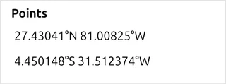
Dragging points on the map is not the only route. The main-window button View and edit graphic’s coordinates opens a panel that lists the selected graphic as numbers you can edit, which is what you want when a position comes from an order rather than from the map.
The panel handles position only — there is no elevation field in it, and no way to type a height for a point. Where map.army needs an elevation it takes one from an online elevation service rather than from you, so a figure that matters for your task (a range regulation, a live-fire safety calculation) has to be carried outside the application.
The panel holds:
| Section | What it holds |
|---|---|
| Attributes | Attitude, Length, Radius and Width, as applicable to the graphic type |
| Direction | A bearing from 0 to 360 |
| Points | One coordinate field per point of the graphic |
| Apply Changes | Commits your edits |
With nothing selected the panel shows No Graphic Selected — select a symbol or graphic on the map first. Apply Changes appears only once you have changed something, so its absence means the panel has nothing to commit rather than that it is broken.
Change the attributes of the tactical graphic
Depending on the type of tactical graphic, certain attributes can be added or changed for this in the MSS Symbol Editor.