On this page
Map display settings: style, labels and terrain
This section describes the settings for the display of the maps in map.army.
Overview
Here you have the option of defining the graphic display.
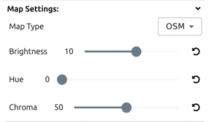
Map Type

Chooses the map drawn underneath your symbols. map.army ships 18 of them from 8 providers, plus a None entry that leaves the background blank — general-purpose maps, satellite imagery, OpenStreetMap and OpenTopoMap, and the official survey maps of six countries.
The full list, what each one is good for, and which may be republished is on its own page: Base maps. Changing it takes effect immediately and never moves your symbols.
Some base maps are published in several variants. When you pick one of those, a second, unlabelled dropdown appears directly beneath Map Type offering the variants, with an Automatic entry that picks one for the zoom you are at. Today the Swiss National Map is the only one that offers this, where the variants are swisstopo’s printed scales — see Base maps.
Brightness
This setting defines the brightness of the map. It goes from -100 (black) to +100 (white). The default is 0.
Hue
In the case of coloured maps, the hue can be changed between 0 and 360. The default is 0.
Chroma
Shows the maps in gradations between coloured (100%) and greyscale (0%). The default is 100%.
Last updated: