On this page
General Options — Language, Work Mode, Units
This section describes the settings and options of map.army.
Overview
The Options window is one scrolling panel, divided by bold headings into six groups: General, Unit Settings, Map Settings, Symbol Format, Performance & Quality Setting and Application Settings. Scroll the panel to reach the lower groups — they are not separate tabs or pages.
A seventh group, 3D View Settings, appears only while you are in the 3D map view — it holds settings that only mean something in 3D, such as terrain exaggeration, contour lines and sunlight. Each of them is described under 3D View Settings.
Inside Map Settings, two further headings subdivide the list: Map Tools and Coordinate Settings. These are separators within that group rather than groups of their own.
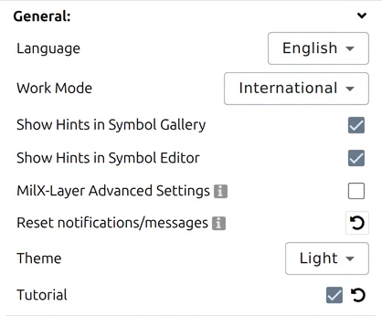
The General group holds the application-wide settings of map.army, described below.
Language

The application language is chosen from a drop-down list. The following UI languages are currently supported: Dutch, English, French, German, Italian, Japanese, Korean, Polish, Portuguese, Spanish and Thai. The language setting is used for both the application user interface and the military icons.
Work Mode

The Work Mode setting decides which symbol sets the gallery offers. It has two values:
- International — international symbols according to MIL-STD-2525, plus a few map.army extensions. This is the default.
- Extended — the country-specific symbols used in Switzerland, as defined in the various regulations and military standards, together with most of the international set. The two galleries are not identical: some international groups appear only in International. See Work Modes for the full comparison.
Extended also includes civil-protection symbology — police, fire-rescue, and civil-emergency symbols following the Swiss police symbology standard (Polizei — Führung im Polizeieinsatz). These categories are visible in the gallery only in Extended mode.
.milxlyz (see Layers → Export Overlays) before changing Work Mode so you can re-import if anything is lost.Show Hints in Symbol Gallery

Controls whether hovering a symbol in the gallery shows its details. With it on you get five lines — Short Name, Abbreviation, Alias, Full Name and Symbol Code. With it off the tooltip is empty.
It changes the tooltips only. Nothing in the gallery stops working.
Show Hints in Symbol Editor

The same idea one level down: the hint icon beside each modifier row in the Symbol Editor explains what that modifier is, showing its name, its modifier number and a description. Switch this off and those explanations are empty.
Leave both on while you are learning the symbology — the modifier hints in particular are the fastest way to find out what a MIL-STD-2525 modifier field is for.
MilX-Layer Advanced Settings

The advanced MilX layer settings include the option to convert the MilX layer to a different coordinate system and / or to an older MilX version before downloading it.
Reset notifications/messages

This resets the saved choices for dialogues, notifications and messages.
Theme

Switches the application between the Light and Dark colour schemes. The setting applies to the map.army interface — panels, toolbars and dialogs — not to the map itself; use Map Settings to adjust how the base map looks.
The row appears only when more than one theme is configured. The public map.army configures two, so you will see it.
Tutorial

Switches the built-in tutorials on and off. They are not a guided tour and nothing runs as a sequence at start-up: each tutorial is attached to one control and appears the first time you hover over it, once. The ones that ship cover reordering symbols within and between layers, downloading layers, the per-layer symbol-format override, and 3D navigation.
The toggle and the reset beside it do different things, and the difference is the useful part:
| Action | What happens |
|---|---|
| Switch off | Tutorials you have not yet seen stop appearing. |
| Switch back on | Those unseen tutorials are armed again — but ones you have already read stay read, so nothing you have seen replays. |
| Reset | Marks every tutorial unseen again and restarts the system. This is how you replay one you have already dismissed. |
Unit Settings
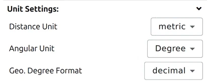
In this area you can set the units for distance and angle.
Distance Unit
Three systems are available:
| Setting | Base units |
|---|---|
| metric | metres and kilometres |
| imperial | feet and miles |
| nautical | nautical miles — for maritime and aeronautical work |
This one setting governs distances, areas and elevations everywhere in the app; there is no separate unit for area.
Angular Unit: degrees or NATO mils
Angles can be displayed in degrees (1 full circle = 360°) or NATO mils (1 full circle = 6400 mils).
Time zone
Sets the time zone used when a date and time is displayed or entered. The default is Z (+0) — UTC, the convention in military reporting. The chosen zone applies wherever map.army shows a timestamp, including the Date&Time field whose format characters are listed below.
Each MilX layer remembers the time zone it was created in, as a military zone letter. Open layers made in another zone and map.army warns you: The following layers were created in a different time zone: followed by their names. That keeps date-time groups (DTG) from different units from being read in the wrong zone.
Geo. Degree Format
Sets how latitude and longitude are written wherever the app prints them:
| Setting | Looks like |
|---|---|
| decimal | 47.3769° |
| sexagesimal | 47°22'36.84" — degrees, minutes and seconds |
The choice applies to the cursor coordinate readout, the coordinate search and the point editor.
It is independent of the coordinate grid drawn on the map. The grid — MGRS, UTM and the rest — is a set of lines over the map; this setting only decides how WGS84 latitude and longitude are printed as numbers. See Coordinate settings.
Date and time format
The Date&Time setting offers a list of ready-made date-time-group formats — you pick one rather than typing your own. The table below explains the characters those presets are built from, so you can read a preset and tell what it will produce:
| Sign | Description |
|---|---|
| Year | |
| yy | Year with 2 digits (00-99) |
| yyyy | Year with 4 digits (0000-9999) |
| Month | |
| m | Month as number without leading zero (1-12) |
| mm | Month as number with leading zero (01-12) |
| mmm | Name of month as abbreviation (depends on the server, for example: Jan) |
| mmmm | Name of month (depends on the server, for example: January) |
| Day | |
| d | Day as number without leading zero (1-31) |
| dd | Day as number with leading zero (01-31) |
| ddd | Name of day as abbreviation (depends on the server, for example: Sat) |
| dddd | Name of day (depends on the server, for example: Saturday) |
| Hour | |
| h | Hour without leading zero (0-23) |
| hh | Hour with leading zero (00-23) |
| am/pm | The time is displayed in 12 hour format |
| a/p | The time is displayed in 12 hour format |
| Minute | |
| n | Minute without leading zero (0-59) |
| nn | Minute with leading zero (00-59) |
| Second | |
| s | Second without leading zero (0-59) |
| ss | Second with leading zero (00-59) |
| Signs | |
| ‘:’ | German time separator |
| ‘\’ | English date separator |
| ‘Xyz’ | Characters enclosed in double or single quotation marks are displayed as text |
| Local specific Date-time strings | |
| ddddd | Use the server’s specific short date format |
| dddddd | Use the server’s specific long date format |
| t | Use the server’s specific short time format |
| tt | Use the server’s specific long time format |
Performance & Quality Setting

Controls how much rendering effort map.army spends on military symbols. Four values, from most detailed to fastest:
- Highest Quality
- Optimal Quality
- Optimal Performance
- Best Performance
Lower the setting if the map feels sluggish while panning or zooming a layer with many symbols; raise it for printing and exporting, where sharpness matters more than responsiveness.
Application Settings

Saves or restores your own map.army preferences as a file — useful for moving a configured setup to another machine or browser, and for restoring it after clearing browser data.
- Download Settings as a file — writes the current settings to a file you keep.
- Load Settings from a file — reads settings back from such a file.
The file holds your symbol format, the display, map and 3D-scene settings, which panels are open, and the definitions of any vector or image layers you have added — the reference to where such a layer comes from, not its content.
This is not a backup of your map. A settings file contains no MilX layer, no other layer and no symbol, so loading one back gives you a familiar-looking application and an empty map. Readers have lost work to exactly this — the file downloads, it reloads without an error, and nothing of the situation is in it.
To keep your work, save the layers themselves with Save MilX and reopen them with Load MilX. The application says as much on its own export dialog: “Please use the ‘Save as MilX’ feature to save your layers locally.” See Export Overlays.
After a successful load the application confirms it and asks you to restart: “Settings were successfully loaded. Please restart the application for the changes to take effect.” Until you do, some of what you loaded will not be in force.
Last updated: