On this page
Map Controls: Right-Click Menu, Selection, Symbol Scale
The controls that work directly on the 2D map — the right-click menu, selecting graphics, and the two sliders that appear when symbols are scaled or spread apart.
The right-click menu
Right-click the map to open its menu. On a touch screen, touch and hold the map instead.
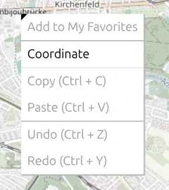
The menu always lists the same commands; the ones that cannot do anything right now are greyed out. On an empty map with nothing selected, that is everything except Coordinate.
| Command | What it does | Available when |
|---|---|---|
| Clear Selection (Esc) | Deselects all selected graphics | listed only while graphics are selected (see Select several graphics) |
| Enable reference line / Disable reference line | Shows or hides the line that joins a moved-apart symbol to its true position | listed only for a symbol that has been spread apart by Decluster Symbols |
| Add to My Favorites | Adds the selected symbol to My Favorites in the Symbol Gallery | a symbol is selected |
| Coordinate | Drops a label with the position and altitude of the point you clicked — see below | always |
| Copy (Ctrl + C) | Copies the selected graphic | a graphic is selected |
| Paste (Ctrl + V) | Pastes the copied graphic into the active layer | something has been copied and a layer is active |
| Undo (Ctrl + Z), Redo (Ctrl + Y) | Undoes or redoes your last change | there is a change to undo or redo |
While you place an image layer with reference points, the menu shows Image Point A–C and Map Point A–C instead — see Place an image with reference points.
Read a coordinate and its altitude
Right-click a point and choose Coordinate. A label appears at that point with its position in WGS84 and the altitude of the ground there, above mean sea level, in metres and feet:
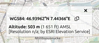
- The copy button next to the position copies it to the clipboard, ready to paste into an order or a message.
- The line under the altitude names its source, an online elevation service.
- The × closes the label.
To read the position under the mouse continuously instead, switch on Display Cursor Coordinate — see Map tool settings.
Select several graphics
| To… | do this |
|---|---|
| select one graphic | click it |
| add a graphic to the selection, or take it out again | Ctrl + click it |
| select everything in an area | hold Ctrl and drag a rectangle — every graphic lying completely inside it is selected |
| move the whole selection | drag one of the selected graphics |
| clear the selection | press Esc, Ctrl + click an empty spot on the map, or choose Clear Selection (Esc) from the right-click menu |
Selecting works on the active layer only — graphics on other layers are left out, even when they lie inside your rectangle. On the map, Shift + click does not add to the selection (in the symbol list of the layer panel it selects a range — see keyboard shortcuts); while you edit a tactical graphic it removes a point instead (see Edit Multi-Point Tactical Graphics).
Scale and spread out 1-point symbols
Two options under Options › Symbol Format › 1-Point Symbols each add a slider at the bottom left of the map — see Scale Symbols and Decluster Symbols for the options themselves:
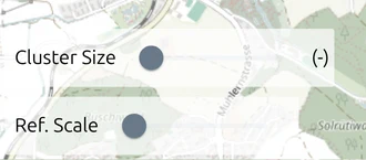
- Ref. Scale appears with Scale Symbols. It sets the map scale from which 1-point symbols start to shrink as you zoom out. Closer in, they keep their full size.
- Cluster Size appears with Decluster Symbols. It sets the distance below which 1-point symbols count as crowded and are spread apart, each with a reference line back to its true position. The value in brackets is that distance; it reads (-) until you move the slider. The range runs from 1 m to 100 km.
Both only change how the symbols are drawn — their coordinates stay where they are.
Magnifier lens
Hold D on the 2D map to open a magnifying circle around the mouse pointer. Symbols that are clustered under it are pulled apart for as long as you hold the key, so you can read a crowded spot without changing any settings. Turn the mouse wheel while holding D to make the circle larger or smaller. The lens is not available in the 3D view.
See also the full list of keyboard shortcuts.