On this page
Magnetic declination in map.army — true vs magnetic north
A compass does not point at true north. The difference between true north (geographic) and magnetic north (where the needle points) is the magnetic declination, and it changes with where you are standing. map.army computes it for you and shows it on the map.
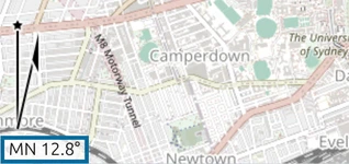
Show magnetic north on the map
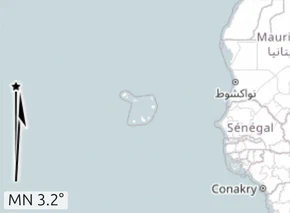
Switch on Display Magnetic North under Options → Map Settings → Map Tools — see Map tool settings.
The map then shows the direction to magnetic north and the declination from true north. The readout is labelled MN, for magnetic north, with the angle beside it — MN 3.2°. The app states how it computes that figure: at the centre of the displayed map section. Pan the map and the value updates, because declination is a property of the place, not of the map.
Which model the figure comes from
Declination drifts as the Earth’s magnetic field moves, so any declination figure is only as good as the model behind it and the date it was computed for.
map.army uses the World Magnetic Model (WMM), the international standard maintained by NOAA/NCEI and the UK Defence Geographic Centre, and used by NATO, the US Department of Defense, the FAA and the IHO.
| Model edition | Epoch | Valid for |
|---|---|---|
| WMM-2025 | 2025.0 | 2025 to 2029 |
WMM is reissued every five years. map.army is updated when the next edition is published.
Bearings: you get both, always
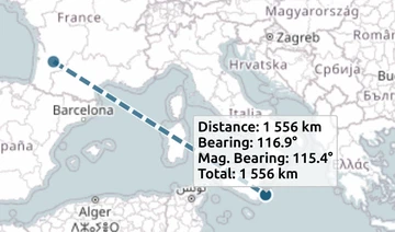
When you measure a distance, map.army reports the bearing twice — once relative to true north and once relative to magnetic north, one above the other.
There is no setting to choose between them, because you never have to: both are on screen. The magnetic bearing is the true bearing corrected by the WMM declination at the start point of the measured segment.
Angular Unit, under General Options, decides whether those bearings read in degrees or NATO mils (6400 to a full circle). It changes the units only — not which north they are measured from.
Grid north and the GM angle
Military map work often needs a third north: grid north, the north of the coordinate grid’s own meridians, which diverges from true north as you move away from a grid zone’s central meridian. The angle from grid north to magnetic north is the GM angle, and it is what a printed military map’s declination diagram gives you.
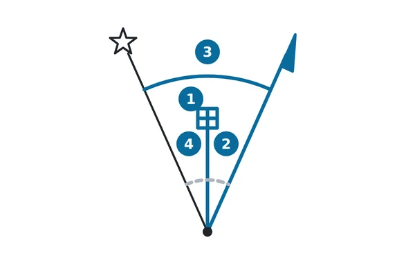
In the diagram: (1) grid north; (2) the GM angle, from grid north to magnetic north, which the app does not compute (dashed); (3) the declination, from true north to magnetic north, which is what the app reports (solid); (4) the grid convergence, from true north to grid north, also not computed (dashed).
The difference matters most at high latitudes and near the edges of a UTM or MGRS zone, where convergence is largest. Near a central meridian it is small enough to ignore for most planning.
Point the map at north
- In 3D view, click the compass (the round heading button at the bottom-left) to turn the view to north. The 2D map has no compass.
- In 3D view, you can also press N to face north — see 3D map view.
There is no one-click “rotate to magnetic north”. Keep the view in true north and read the declination from the indicator.
Declination is local
Declination differs measurably across a single theatre, so a value read in one place is not the value somewhere else. When you plan across a wide area, do not carry one declination figure across the whole of it — pan to the area that matters and read it there, or take the per-segment figure from a measurement.
Last updated: