On this page
Add Your First Military Symbol — map.army Quick Start
This quick-start tour walks you through placing your first MIL-STD-2525 symbol on the map in map.army — from picking an active layer to setting modifiers in the symbol editor.
Overview
map.army supports two families of MIL-STD-2525 symbols:
- Military 1-Point Symbols — single-point unit and equipment symbols placed at one map location (an infantry company, a command post, an artillery battery).
- Military N-Point Symbols — tactical graphics drawn across several points to depict a line, area, or movement (front lines, boundaries, axis-of-advance arrows, fire-support coordination measures).
This first-symbol tour walks you through the 1-Point case end-to-end. The same workflow applies to N-Point graphics — you click each point in sequence to draw the geometry. The demo below shows the full placement:
Activate a drawing layer
A project in map.army can hold multiple military map overlays (drawing layers). To place or edit symbols, you first mark one of them as the active layer — drawing operations apply only to the active layer at any given moment. To activate a drawing layer:
Click Map Overlays.

Choose the layer to draw on and set it as Active Layer.
The pen icon next to the layer name confirms the layer is active.
Place your first symbol on the map
With an active layer set, the Add new MSS Symbol button in the top-right corner of the main window becomes available. To place your first military symbol on the map:
Press Add new MSS Symbol.

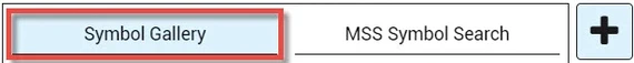
Open the Symbol Gallery or start an MSS Symbol Search.
Select a military symbol and move the cursor onto the map.
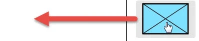
Click on the map to place the symbol.

Customize the symbol with the MSS Symbol Editor
A placed base symbol can be tailored to your tactical situation in the MSS Symbol Editor. The editor exposes the symbol’s affiliation (friend, hostile, neutral, unknown), echelon (squad through corps), status (present, planned, anticipated), and the textual modifiers that surround it — unit designator, higher formation, additional information, dates and times. The preview updates live as you edit.
Select the base symbol on the map.

The MSS Symbol Editor button is now active — press it to open the editor.
![Military Symbology Editor in [map.army]](https://www.map.army/doc/img/common/MilitarySymbologyEditor_Button_hu_ec761d26dbd90a95.webp)
Change any modifier or attribute in the editor by clicking the corresponding field, then picking a value or typing a label.
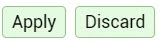
Press Apply in the footer to commit your changes, or Discard to revert and close the editor.
For the full list of modifiers and attributes — and notes on what each one represents in MIL-STD-2525 — see the MSS Symbol Editor reference.