On this page
Export a Military Map to PDF, PNG or GeoTIFF
An export turns the situation on screen into a file you can send, print or load into GIS software. map.army exports to PDF and to image formats, and in both cases you control the area, the size and what is drawn into it.
Open the export panel
Click the
 Print map or Export to PDF button on the left edge of the main window.
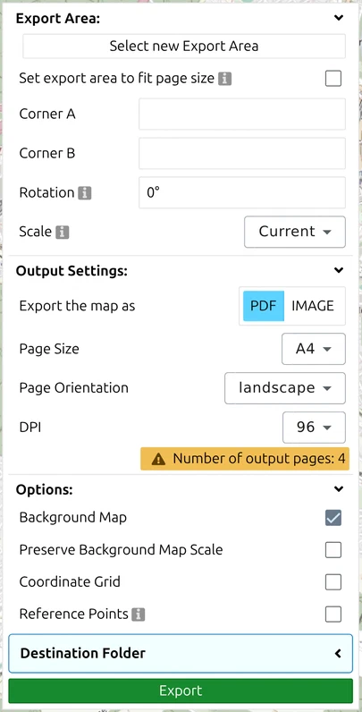
The panel opens with three collapsible groups — Export Area, Output Settings and Options — followed by Destination Folder and the Export button at the bottom. Work down them in order.
Choose the export area
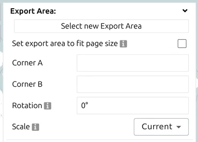
By default the export covers what you can see. The Export Area group lets you define it deliberately instead:
| Control | What it does |
|---|---|
| Select new Export Area | Drag a rectangle on the map to set the area |
| Corner A / Corner B | The two opposite corners, as coordinates you can read or type |
| Rotation | Turns the export frame in degrees, so a road or valley can run straight across the page |
| Set export area to fit page size | Snaps the area’s proportions to the paper you chose, so nothing is trimmed |
| Scale | Automatic, Current (the scale you are viewing at), or a fixed scale from 1:1 000 up to 1:25 000 000 |
Rotation is the control people miss. An area of operations rarely lines up with north, and rotating the frame usually beats shrinking the scale to fit an awkward diagonal onto the page.
Output settings — PDF
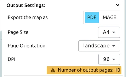
With Export the map as set to PDF:
| Setting | Notes |
|---|---|
| Page Size | A0 to A5, plus Letter. A4 by default; the larger sizes suit briefing prints |
| Page Orientation | Portrait or landscape |
| DPI | 96, 150 or 300 dots per inch. 96 suits a screen; print wants 150 or 300 |
| Number of output pages | Not a setting but a readout: the panel tells you how many pages your current area, scale and paper size will produce |
Watch that page count. If it says four pages when you wanted one, the area is too large for the scale and paper — reduce the scale, choose a bigger page, or use Set export area to fit page size.
A higher DPI really does fetch a sharper background map — up to a point. The export asks the base-map service for the zoom level that matches the DPI you chose, so 300 dpi pulls finer imagery than 96 dpi rather than simply enlarging what is on screen. That holds until the source runs out of zoom levels; past its sharpest level there is nothing more to fetch and the extra dots only make the same detail bigger. So if a 300 dpi export of a remote area is still soft, you have reached the limit of that base map — try another one rather than raising the DPI again.
Switching Preserve Background Map Scale on deliberately turns that off: the background is then pinned to the level of detail you see on screen and scaled up to fill the page. Use it when the printed map has to match the screen, and leave it off when you want the sharpest background the source can give.
Output settings — image
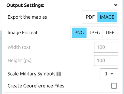
With Export the map as set to IMAGE:
| Setting | Notes |
|---|---|
| Image Format | PNG, JPEG or TIFF |
| Width (px) / Height (px) | The output size in pixels |
| Scale Military Symbols | 0.5, 1, 2 or 3 × — draws the symbols larger or smaller relative to the map; 1 is normal |
| Create Georeference-Files | Writes the sidecar world file described below |
Scale Military Symbols is what you want for a large-format plot. Blown up to A0, symbols sized for a screen look lost; a factor of 2 or 3 keeps them readable at arm’s length. It does not move anything — only the drawn size changes.
Choose what the export contains
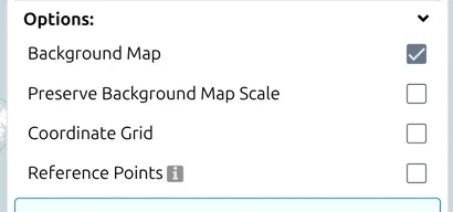
The Options group decides what is drawn into the file:
| Option | Effect |
|---|---|
| Background Map | Include the base map, or export the symbols over nothing — useful for an overlay to lay on another map |
| Preserve Background Map Scale | Keeps base-map labels and detail at their on-screen scale instead of rescaling them with the export |
| Coordinate Grid | Draws the coordinate grid into the export |
| Reference Points | Adds marked reference points, an aid for whoever has to georeference the output by hand |
You can also override the grid interval (in metres) and the coordinate-label interval rather than accepting the on-screen spacing. Leave either at 0 to keep the default. With Reference Points switched on you place points #1 and #2 and set their line width, 1 to 10 px.
Overlay trace on foil. Switch Background Map off and Reference Points on, then print on transparent foil: the two reference points let you lay the overlay exactly over a paper map of the same scale.
Classification marking. The export has no title, header or classification field; its footer is fixed. To mark a printout (for example NATO UNCLASSIFIED at the top and bottom), place a text generic graphic inside the export area before you export. For real confidentiality metadata in a file, use NVG export.
Where the file goes, and stopping it
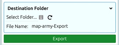
Set a Destination Folder and file name before exporting, and the file is written straight there. If the browser cannot write to the folder, or a file of that name already exists, the app says so rather than failing silently — it may also save under a slightly different name, so check what actually landed.
A large export is not instant. While it runs, a progress overlay lists the stages it is working through and offers Abort, which is the right response to a page count you did not intend.
Georeferenced output

A georeferenced export carries the information GIS software needs to place the image on the globe. There are two routes:
- TIFF stores the georeference inside the image file. Nothing can be separated from it, which makes it the safer choice for handing on. This is why the separate georeference-file option does not apply to TIFF.
- PNG or JPEG with Create Georeference-Files produces a sidecar world file —
.pgwbeside a PNG,.jgwbeside a JPG. Keep the pair together; alone, the image is just a picture.
A world file holds six numbers, one per line:
A    pixel size in the X direction
D    rotation about the Y axis
B    rotation about the X axis
E    pixel size in the Y direction (usually negative)
C    X coordinate of the centre of the upper-left pixel
F    Y coordinate of the centre of the upper-left pixel
The values are in the coordinate system of the exported image. map.army writes world files in WGS84, so A and E are degrees per pixel, not metres. To get a metric pixel size, multiply by roughly 111 320 m per degree at the equator — the longitude factor shrinks toward the poles. The format is a public standard; see the World file article for the full specification.
Attribution when you publish
The base map draws its own credit line onto the map — naming the data source, such as OpenStreetMap or swisstopo — and that credit is part of the map, so it appears in an export that includes the background map. It is not an export setting you can switch on or off.

Exporting without the background map removes the credit along with the map — which is legitimate, because there is then no base-map data to credit. Your own symbols are yours.
The licence terms for symbol use, modification and redistribution are summarised in the FAQ.
Pick the right base map before you publish

Which base map you export over matters as soon as the result is published:
- OpenStreetMap and OpenTopoMap may be redistributed with the usual attribution. These are the safe defaults for anything printed or public.
- Google base maps — Maps, Satellite, Hybrid, Roads — may not be redistributed in print or static publication under their terms. Use them while working, then switch before exporting.
- swisstopo follows swisstopo’s open-data terms, mostly permissive for non-commercial use; check the current licence for commercial work.
Switch under Options → Map Settings → Map Type; see Options → Map Settings.
Last updated: