On this page
Free vs Pro — What Each map.army Tier Includes
map.army is available in two flavours: a free hosted demo at www.map.army — what this documentation site describes — and a professional offering (map.army pro) delivered on a project basis. The free version is sufficient for most planning, training, and hobby use. The professional version adds capabilities aimed at organisations that need multi-user operation, live tracking, or on-premise deployment.
At a glance
| Capability | Free hosted | map.army pro |
|---|---|---|
| MIL-STD-2525 symbology via MSS | ✓ | ✓ |
| 2D and 3D map view | ✓ | ✓ |
| MilX layer create / edit / import / export | ✓ | ✓ |
| Coordinate grids — MGRS, UTM, WGS84, GARS, BNG, LV95, LV03, SLD99, Kandawala, Hexagonal | ✓ | ✓ |
| Coordinate search and measurement tool | ✓ | ✓ |
| SDZ / range fan builder (Safety Distance Zones) — sector of fire, direction of fire, ricochet, vertical hazard, saved weapon types | ✓ | ✓ |
| NVG import and export — ADatP-4778 interoperability | ✓ | ✓ |
| PDF / image export, with the base-map credit | ✓ | ✓ |
| Share via read-only / edit-copy / edit-overwrite link | ✓ | ✓ |
| Iframe embed | ✓ | ✓ |
| Own browser geolocation (your position only) | ✓ | ✓ |
| Timeline & unit animation — units follow planned routes between waypoints with playback controls | — | ✓ |
| Blue Force Tracking (BFT) — real-time position sharing between participating units | — | ✓ |
| External GPS / SIM-tracker integration — hardware beacons pushing positions into the map | — | ✓ |
| User administration & logins — multi-user collaboration with role-based permissions | — | ✓ |
| Custom WMTS / WMS base maps — private and on-premise tile servers as the app’s map providers | one per link | ✓ |
| Password-protected shares — non-public links requiring authentication | — | ✓ |
| Closed-network / on-premise deployment — runs without internet, with the MSS / MilX backend on-site (Linux + Apache or Windows) | — | ✓ |
On custom base maps: the hosted version takes one WMTS or WMS service of your own, passed in the link as a mapType parameter, which then replaces the built-in list for that session — see Connect Your Own Map Service. Having your services be the map list, selectable from the Options panel alongside or instead of the public providers, is configured per deployment and is the pro capability.
What the free hosted version is for
The free hosted version exists to demonstrate the MIL-STD-2525 symbology services (MSS and MilX) developed by gs-soft AG, and to give planners, students, and hobbyists a working tool for drawing tactical situations. It is suitable for:
- Solo planning of exercises, missions, or wargames.
- Training and teaching military symbology.
- Producing PDFs and printed maps for hand-out or post-exercise review.
- Sharing a situation read-only with stakeholders via a public link.
There is no account, no login, and no cost. Save your work regularly by exporting .milxlyz files (see Layers → Export Overlays) — the hosted backend has no per-user persistence.
What map.army pro adds
The four capability blocks above (timeline, BFT, user admin, custom base maps) are the headline differences, but in practice the more important difference is the deployment model:
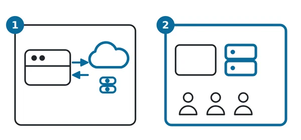
In the diagram: 1 the free hosted version, where the browser reaches cloud services; 2 map.army pro, run on-premise or on a closed network with long-lived user accounts.
- Project-based delivery. map.army pro is not a self-service signup. Each deployment is scoped to the customer’s environment — Active Directory integration, existing GIS infrastructure, preferred WMTS / WMS providers, isolation level — and delivered as a project by gs-soft AG together with an industry partner where appropriate.
- On-premise or closed-network operation. The full backend (MSS, MilX, web app) runs without internet access. This is how map.army is used inside several command-and-control, C4I, and military simulation environments today.
- Long-lived state. Pro deployments have actual user accounts and server-side project storage. The free hosted version intentionally stores nothing per-user.
- A local MilX working folder. A pro or closed-network deployment can keep MilX layers in a folder you grant it and offer them back at the next start — “Do you want to reload the last used MilX Layers?”. This is switched off in the free hosted application, which is why Session persistence describes no local draft: that is true of the hosted app, not of every build.
Adjacent gs-soft products for offline / desktop work
If the gap you have is offline operation rather than the pro features above, two desktop tools from gs-soft cover that scenario:
- MssDraw — Windows desktop application for drawing and composing military situations offline. Also converts
.milxlyzto.kmzfor Google Earth / ESRI Earth use. - MssComposer — Windows desktop application for composing higher-level situations and reports.
These are not part of map.army pro but solve the same offline-use problem for individuals without requiring a project deployment.
What a pro deployment looks like in practice
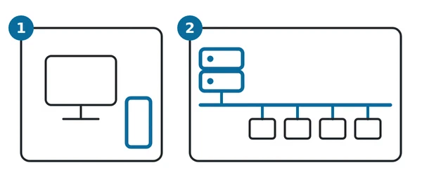
Two shapes cover almost every enquiry. Which one fits depends on how many people need the map and whether they share a network:
| Shape | Runs on | Suits |
|---|---|---|
| Local install (1) | One Windows PC | A single planner, a classroom machine, or a laptop taken somewhere with no network at all |
| Network hosting (2) | A Windows Server on your own network | A staff, a course, or an operations room where several people work on the same closed network |
Both run the full stack — web application and the MSS and MilX backend services — on your own hardware, with no traffic leaving your network. Both can draw their background maps from your map services over WMS or WMTS rather than from the public providers, and both exchange overlays with other systems through MilX and NVG.
Deployments normally start with a trial period, so the staff who will use it can try it on their own network before anything is committed. Licensing after that is project-based and scoped to the number of end users, sold as a perpetual licence with an optional annual maintenance agreement.
Enquiries that touch the backend services themselves — the REST API, the SDKs, or source access for embedding map.army in another product — need a signed NDA before the material can be shared. Demo and developer licences are free.
How to get map.army pro
Pro is not publicly priced or sold. To discuss a deployment, contact gs-soft AG:
Typical first steps are a requirements call covering deployment topology, intended user count, base-map sources, and any custom symbology needs. See also the FAQ entry on closed-network deployment under FAQ — Can the web application map.army run on a closed network?.
Last updated: